


Crash and collision investigation

可以大大简化和改进的小型或大型道路和交通事故场景的快速而全面的文件,例如车祸,大规模碰撞,火车事故或飞机坠毁。即使在昼夜或黑夜难以到达地点,在雪,雨和雾之类的不利天气条件下,现场也需要记录在现场。
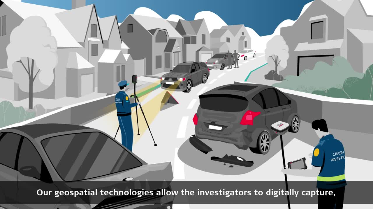
Our digital geospatial technologies capture all details of a crash scene in 2D or 3D in a matter of minutes. They document and visualise marks made by rolling, braking, locking, drifting, or skidding of the involved vehicles. The results show the relative location of all direct and related evidence. Our solutions ensure sufficient and accurate information is gathered when identifying and recording evidence onsite. Save valuable time and resources by completing fieldwork quickly and have all the information needed by stakeholders to revisit the incident at any time, from any location.
Contact our Public Safety, Security and Forensics experts
捕获碰撞现场的完整而准确的数据,并快速重新开放道路
Use the power of our automation and digitalisation technology to document every detail of a crash scene quickly and safely. Whether you need the simplicity of single measurements for basic 2D diagrams, comprehensive point clouds for immersive 3D flythroughs and animations, or the flexibility to determine the best approach on scene, our solutions give you the insights you need to clear collision locations fast.

Revisit the Forensic Digital Twin of the accident scene and re-examine later every detail
我们的三维激光扫描技术允许您,ckly and efficiently capture an entire crash scene and generate a point cloud in real-time. The point cloud provides a measurable model, allowing you to view it as a Forensic Digital Twin - the 3D virtual replica of the real-life scenario.

Being aware of environmental conditions for conducting documentation and investigation of traffic accidents can play a significant role
在交通事故中,与其他户外事件(例如犯罪或消防/纵火景场景)一样,执法机构进行视觉检查并在所有环境条件下保留证据。无论雨水,冰雹,雪或极高的热量如何,都必须完成工作。记录大型场景可能是一个漫长的过程,需要在白天或晚上进行。我们的投资组合提供多功能和强大的解决方案,即使是最具挑战性的条件。
发现我们的主要解决方案用于崩溃调查和碰撞重建
Handheld and accurate in-picture measurement solution for collision documentation

使用Leica BLK3D捕获崩溃或碰撞现场
TheBLK3Dis a measurement solution based on photos. Each photo captured is a complete measurement record that contains height, width, and depth measurements. Measurements can be created at any point, right away onsite, or at any point in time thereafter using the BLK3D Desktop Software.
The BLK3D enables you to easily measure even in hard to reach areas. It helps to avoid transposed digits and missing or inaccurate measurements. Police officers or crash investigators can document small to medium-sized crash scenes directly onsite.

使用集成的BLK3D软件管理和交付数据
Export 3D images in PDF or JPG format from your PC or from the BLK3D via WiFi. Send 3D images captured by the BLK3D to your computer, where they can be opened and managed with theBLK3D桌面软件.
捕获的3D可测量图像可用于创建高级PDF报告2D图和图片,并使用3D图表测量。几乎在崩溃位置被清除后很长时间后,几乎都会重新审视坠机现场。
事故文档的视觉位置和即时映射

捕获坠机或与Leica GS18 I GNSS RTK ROVER碰撞或碰撞
Measure hundreds of previously inaccessible points in minutes, from a safe distance in a matter of minutes, simply by walking around the scene. The dense point clouds derived from the photographs captured with theGS18 iintegrated Visual Positioning technology provide centimetre positioning quality that can aid in the visualisation of a collision or crash scene.
Ensure completeness of evidence and revisit the scene from the office as needed to proceed with your investigation with confidence, thanks to the system’s ability to extract the exact location of evidence.

Manage and deliver the data with Leica Infinity
Use onboardLeica Captivatesoftware to capture, measure and process data in the field, andLeica Infinityto measure points or create a point cloud from the data back in the office and without disturbances from weather or traffic. Infinity software is designed to manage, process, analyse and quality check all field survey data from GNSS sensors, total stations, digital levels, and UAVs.
Fast, agile, and precise crash scene documentation and forensic mapping for court-ready deliverables

Capture the scene with the Leica RTC360
与RTC360 3D laser scanner,碰撞场景可以在不到两分钟的时间内以每秒200万点捕获,并在现场预注册。通过在RTC360上启用了双扫描功能后,自动删除了最终点云数据中的人或车辆等移动对象。

用狮子旋风域360和莉卡旋风寄存器360来管理数据
The captured scan data is pre-registered in the field and displayed in real time in the旋风场360移动设备应用程序,允许用户进行现场扫描质量控制检查。
Quickly post-process scenes in the office withCyclone REGISTER 360软件。

Deliver a wide array of deliverables with Leica Map 360
Map360 is the solution for complete scene reconstruction with the flexibility to import your data from a wide range of sensors. Analyse your scene with intuitive tools, such as crush analysis, momentum angles, QA protocol and witness views.Map360helps you to easily transform your 3D crash scene data into an accurate and compelling Forensic Digital Twin.
Contact our Public Safety, Security and Forensics experts

Mapping crashes and collisions at record speed
了解如何以创纪录的速度绘制圣安娜警察局。凭借其RTC360激光扫描仪,军官在不到30分钟的时间内捕捉了整个场景,从而缓解了人员压力。
了解如何以创纪录的速度绘制圣安娜警察局。凭借其RTC360激光扫描仪,军官在不到30分钟的时间内捕捉了整个场景,从而缓解了人员压力。

数字记录崩溃场景的原因改善了调查人员的结果
探索如何通过在时间敏感的环境中快速捕获和共享准确,完整的3D模型来大大简化和改进崩溃场景的分析。
探索如何通过在时间敏感的环境中快速捕获和共享准确,完整的3D模型来大大简化和改进崩溃场景的分析。

法医映射:波兰警方使用total stations for crash documentation
阅读Leica TS10总站和Cybid ESURV解决方案如何使波兰警察有可能向崩溃和事故专家提供交通事件的数字文档。
阅读Leica TS10总站和Cybid ESURV解决方案如何使波兰警察有可能向崩溃和事故专家提供交通事件的数字文档。

Why choose us
Peer-to-peer advice, consultancy and practical assistance. We are a partner trusted by public and private sector organisations, offering the broadest portfolio of geospatial tools, reliable service, and expertise.
Peer-to-peer advice, consultancy and practical assistance. We are a partner trusted by public and private sector organisations, offering the broadest portfolio of geospatial tools, reliable service, and expertise.

Applications
Our know-how serves Public Safety professionals worldwide and redefines the way law enforcement personnel manage incident and scene investigation, evidence gathering, and forensic mapping.
Our know-how serves Public Safety professionals worldwide and redefines the way law enforcement personnel manage incident and scene investigation, evidence gathering, and forensic mapping.

解决方案
Our solutions for reality capture, scene investigation or reconstruction, precise positioning and location intelligence give you the edge in creating your Forensic Digital Twin.
Our solutions for reality capture, scene investigation or reconstruction, precise positioning and location intelligence give you the edge in creating your Forensic Digital Twin.

Learning centre
Whether looking to move beyond traditional documentation methods or master your technology, our training resources support you in every step of your day-to-day job.
Whether looking to move beyond traditional documentation methods or master your technology, our training resources support you in every step of your day-to-day job.