


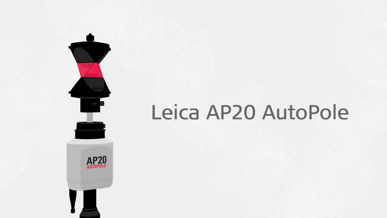
The AP20 AutoPole – Revolutionising Total Station Measurements
Expert Insight

Leica Geosystemsrobotic total stations和多阶段s对于测量和布局的日常调查工作流程至关重要,自动化和软件集成导致生产率的显着提高,对准确测量的信心以及质量可交付成果。
However, working with a survey pole during measurement tasks has been the weak link in this automation chain, with time spent levelling the bubble and recording pole height changes in the software, and the potential for the total station to not find the target on busy sites. To fill in this gap, Leica Geosystems developed theLeica AP20载体– the world’s first intelligent survey pole.
The AP20 is a unique smart solution enabling surveyors to measure with a tilted pole, automatically record height changes in the field software and ensure the total station searches and locks to their target only.
Hannes Maar, Senior Product Engineer at Leica Geosystems with expertise in surveying, introduces the new AP20 and provides insight into how this latest innovation can optimise the surveyor’s workflow with automation.
Innovative and Automated Survey Pole
The Leica AP20 AutoPole is truly a unique smart solution that solves many challenges that surveyors experience today when using a prism pole together with an automated total station. The AP20 is comprised of an intelligent sensor module which communicates with our automated total stations and MultiStations and can be attached onto our new AP Reflector Pole with passive sensing elements. Combined, it is possible to measure points with a tilted pole, automate pole height adjustments and search and lock onto any standard target which is mounted on top of the pole.
支持stakeout and survey tasks to the most extent, the AP20 is designed both for one- and two-person operation. It can be operated directly from the total station or from a field controller or tablet. For these reasons, the AP20 fits flexibly into your existing total station survey setup.

Three Powerful Possibilities for the Surveyor’s Workflow
Each of the AP20’s unique functionalities provides distinct and significant advantages to the surveyor’s workflow.
Tilt compensation是一个功能,使点测量a tilted pole, eliminating the need to level the pole and hold it steady during point measurement. Essentially, the AP20, replaces the individual levelling uncertainty of the pole operator with the certainty of a reliable IMU sensor.
Even when you must drastically tilt a pole to reach a point, you can be confident that the tip of the pole is always the point being measured. Tilt compensation makes points accessible that were previously too difficult to measure or even impossible to reach. At the same time, productivity increases because you can collect data or stakeout a location without slowing down to level the pole.

WithPoleHeight, the AP20 automatically measures the current length of the pole and applies the detected changes inLeica Captivate field software, removing the need to read, check and enter height changes manually in the field software. This also eliminates time-consuming post-processing to fix incorrectly entered or forgotten target heights, saving time in the office as well as the field.
Conditions on sites are rarely static or predictable, you might often need to change the length of the pole to ensure line of sight to the total station over obstacles. With the AP20’s PoleHeight functionality, you can easily adjust the height to accommodate the situation, with the assurance that the correct pole height is always recorded.
Today, our automated total stations and MultiStations are already able to detect what is, and what is not, a target and thereby can filter foreign reflections. Now with the AP20, they can detect if the target isyourtarget.TargetID, enables the total station to uniquely identify your target during search, preventing lock onto other targets. This feature is particularly useful when several surveyors are working on a site together.
Grow Your Business with Automated Surveying
为了通过减少在赌注过程和调查中减少人为错误来优化其工作流程的调查服务提供商,AP20代表了对Leica Geosystems自动化总站的高度价值补充。bob apple由于AP20适合您现有的工作流程并改善了您的现有工作流程,因此在没有过程中断或培训时带来了直接的好处。
Additionally, the combination of tilt compensation, automatic height readings and target identification is unique to the market. It creates benefits of assured measurement quality, transparent reliability in the field and time savings, translating to significant productivity increase while performing survey tasks. Coupled with a robust design, the owner experiences a new kind of easy-to-use and flexible pole operation with the lowest total cost of ownership.

Hannes Maar,
高级产品工程师
联系我们to learn more about how the Leica AP20 AutoPole can optimise your automated surveying workflow.
Lorem Ipsum

联系我们about Total Stations
Get in contact with us for more information about our total station portfolio.
Get in contact with us for more information about our total station portfolio.

Total Station Comparison Chart
Which total station is right for you?
Which total station is right for you?

LOC8 - Theft Deterrence and Location Solution
Protect your total station: always know where your instrument is in the field. Discover the benefits of remotely locking your total station, learn about Geo Fences and more.
Protect your total station: always know where your instrument is in the field. Discover the benefits of remotely locking your total station, learn about Geo Fences and more.

Leica Caintivate培训视频
Training videos show you how to set up, work and get the information needed to complete the job.
Training videos show you how to set up, work and get the information needed to complete the job.

Online Learning
Leica Geosystemshas developed an online learning platform, to further educate customers to use the functionality of their instruments to the maximum.
Leica Geosystemshas developed an online learning platform, to further educate customers to use the functionality of their instruments to the maximum.

联系我们的公共安全,安全和取证专家
Peer-to-peer advice from experienced Public Safety experts
Peer-to-peer advice from experienced Public Safety experts