


Security and Major Incident Management

Expect the unexpected, plan comprehensively and be prepared. The unknown threat is always the most difficult to counter. Our technology creates digital twins of environments in real-time and includes site-specific intelligence. By quickly offering accurate digital mapping and documentation solutions, gathering precise and actionable data can accelerate reaction times and save lives. Security managers, customs- and border protection officers around the world trust our solutions to pre-plan, operate and respond to an incident.
Contact our Public Safety, Security and Forensics experts
预先计划阶段:重大事件的信息情报和风险评估
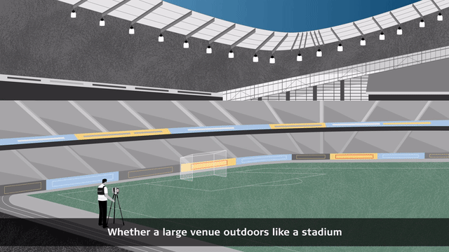
The security of an event is not limited to the space that you or your customer's organisation inhabit. Planning for any event follows a systematic process that simplifies what can feel very overwhelming and time consuming for many event organisers, business owners and security managers.
Whether it be a large venue outdoors like a stadium (to be captured with our3D laser scannersor thePegasus:Backpack)或小型室内场地(用BLK360,BLK3D, 或者BLK2GO),我们的数据捕获和现实可视化解决方案为您提供了所需的信息和威胁智能,并通过风险评估和管理为您提供支持。

操作阶段:物理保护,监视和准备事件响应的准备
Deploying a combination of 3D intelligence from our surveillance solution and overt and covert protective security solutions keeps the public safe and the country borders protected. Security managers, customs and border patrol commands have complete information, are better prepared and can flexibly make and communicate effective decisions.
我们的解决方案让你准备安全、紧急情况ency response, customs, and border protection staff to respond to possible incidents while minimising disruption and maintaining the smooth running of the event or operation.

The post-event and analysis phase
Our激光扫描,UAV, 和mobile mappingsolutions give security professionals, customs and border patrol officers access to high-quality data to effectively map the surroundings for reconnaissance and pre-planning phase as well as the secure operation of the event or mission. Based on the gathered 3D data intelligence, you can analyse the effectiveness of your operation, share your findings with your customers, stakeholders, and commands with theLeica Truview数字现实查看器并适应员工的培训。
发现我们推荐的安全和事件管理解决方案
Professional-grade 3D laser scanner solution for information intelligence

Capture the scene with the Leica RTC360
With theRTC360 3D laser scanner, environments can be captured at up to 2 million points per second in less than two minutes. The RTC360 is a versatile and a robust laser scanner (IP54) and is an ideal solution for outdoor or indoor areas.

用狮子旋风域360和莉卡旋风寄存器360来管理数据
Captured scan data is visualised and pre-registered directly in the field in real-time with the旋风场360app, allowing users to perform quality control and assurance of the data.
Quickly post-process 3D environments in the office withCyclone REGISTER 360软件。

Deliver a wide array of reports with Leica Map360
Our forensic mapping software,Map360is the best solution for complete scene or incident visualisation and reconstruction. Flexibly import your data from a wide range of sensors. Map360 helps you to transform your 3D data into accurate and compelling 3D Digital Twin.
Versatile and wearable mobile mapping solution for gathering location and information intelligence

Wearable 3D reality capturing of the environment indoor and outdoor, above and underground
莉卡Pegasus:Backpack是一种可破坏性的可穿戴系统,可更快地捕获现实,在现场花费更少的时间,并能够在快速变化,具有挑战性和敌对的环境中做出快速而明智的决策。使用点云和图像制作街道和建筑物的3D模型以及地图;平面图和高程模型;现有疏散/出口路线等的2D和3D数据等。这些可交付成果可用于分析现有的上述和地下紧急撤离程序和方案,或用于最佳监视和支持团队安置。
3D smart surveillance system for threat detection and protection

Smart threat detection and intrusion prevention
TheBLK247是一个智能的3D监视系统,可以立即确定具有准确性和可靠性的威胁与非威胁。BLK247传感器融合技术结合了激光雷达,视频和热成像传感器。它通过在3D中执行实时更改检测来监视空间。

Manage the data with Accur8vision
精确8visionis an expanded perimetric security system. Accur8vision guards the entire area of a patrolled space and is suitable for securing large and small areas.

Deliver the results/reports with Smart Surveillance System
增加对安全系统的整体信心。监视整个空间360°水平X 270°垂直视野覆盖范围,并使用3D地理申请定义特定的监视区域。定义警报区。根据您的需求灵活更改保护区。为无法安装围栏和弹兵的地方提供安全性。监控人的运动并防止可能入侵。
Handheld and accurate in-picture measurement solution for site documentation

Capture any space with the Leica BLK3D
Capture 2D images embedded with 3D data with a handheld, professional-grade measurement device the size of a smartphone powered by Android.
TheBLK3D有助于避免移序数字,丢失或不准确的测量值,甚至可以通过拍摄图片进行3D测量。可以在中小型位置进行侦察,急救人员可以轻松记录任何建筑物。

使用集成的BLK3D软件管理和交付数据
Export 3D images in PDF or JPG format from your PC or from the BLK3D via WiFi. Send 3D images captured by the BLK3D to your computer where they can be opened and edited with theBLK3D桌面软件.
The captured 3D measurable images can be used to create advanced reports as pdf with 2D plans, pictures with 3D in-picture measurements, highly accurate 2D and 3D floorplans.
手持3D激光扫描仪与LIDAR和SLAM空间意识技术用于捕获位置和事件场景

移动时以3D捕获场景
TheBLK2GOhandheld imaging laser scanner is a lightweight, easy-to-use mobile mapping solution that’s ideal for onsite security planning, public building documentation or rapid-deployment disaster response. It combines two-axis LiDAR with SLAM spatial awareness technology and视觉惯性系统(VIS)technology to accurately track the scanner’s movement and simultaneously unify point clouds while recreating complex spaces with unprecedented speed.

Manage and deliver the data with integrated Leica BLK2GO software
Send your data into point cloud compatible software and create models, highly accurate 2D floorplans, perspectives and vantage points and other deliverables specific to your work. With the integratedCyclone REGISTER 360 (BLK Edition)借助自动注册,精确的视觉对齐,易于清理以及多个可视化和导出选项,您可以查看,检查,飞行3D点云,并提供对项目的沉浸式可视化。
Contact our Public Safety, Security and Forensics experts

Advanced security work: Anticipate, plan, prepare with the Leica BLK3D Imager
读BLK3D如何帮助安全内核ity professionals gather, correct and complete reconnaissance and threat plan with data, pictures, and measurements of any venue, easily identify vulnerable points, and more.
读BLK3D如何帮助安全内核ity professionals gather, correct and complete reconnaissance and threat plan with data, pictures, and measurements of any venue, easily identify vulnerable points, and more.

在世界上最繁忙的机场之一中捕捉现实
Changi Airport Group used the latest laser scanning technology to maintain one of the world’s busiest airports to the highest standards in the long term without disrupting the constant flow of passengers.
Changi Airport Group used the latest laser scanning technology to maintain one of the world’s busiest airports to the highest standards in the long term without disrupting the constant flow of passengers.

Redefining security and surveillance through sensor fusion
收听BLK247是一种结合LIDAR,视频和热成像功能的智能监视系统,可以自主检测和报告空间内的物理变化。
收听BLK247是一种结合LIDAR,视频和热成像功能的智能监视系统,可以自主检测和报告空间内的物理变化。

Why choose us
Peer-to-peer advice, consultancy and practical assistance. We are a partner trusted by public and private sector organisations, offering the broadest portfolio of geospatial tools, reliable service, and expertise.
Peer-to-peer advice, consultancy and practical assistance. We are a partner trusted by public and private sector organisations, offering the broadest portfolio of geospatial tools, reliable service, and expertise.

Applications
Our know-how serves Public Safety professionals worldwide and redefines the way law enforcement personnel manage incident and scene investigation, evidence gathering, and forensic mapping.
Our know-how serves Public Safety professionals worldwide and redefines the way law enforcement personnel manage incident and scene investigation, evidence gathering, and forensic mapping.

解决方案
Our solutions for reality capture, scene investigation or reconstruction, precise positioning and location intelligence give you the edge in creating your Forensic Digital Twin.
Our solutions for reality capture, scene investigation or reconstruction, precise positioning and location intelligence give you the edge in creating your Forensic Digital Twin.

Learning centre
Whether looking to move beyond traditional documentation methods or master your technology, our training resources support you in every step of your day-to-day job.
Whether looking to move beyond traditional documentation methods or master your technology, our training resources support you in every step of your day-to-day job.